Friday, June 30, 2017

Salisbury

  • Day:  111
  • Start:  1490.6
  • End:  1504.9
  • Miles:  14.3
  • Hours:  9
  • High temp:  84
  • Low temp:  67
  • Thru Hikers met:  4

 
Falls Village High School

The flashes are soothing to watch as I wake about 0200 hrs. Fireflies are in the trees above me and are a delight to watch. As the air cools in the early morning they decide to stop.  It seems like they enjoy the warm summer nights.
I'm in Falls Village by 0630 waiting for the Toymaker Cafe to open at 0700 hrs. 

The Toymaker Cafe

Inside the Toymaker 

Breakfast

The corned beef hash is home made and delicious. 

I enjoy my breakfast with J2, (we helped each other take photos at McAfee's Knob) and Kentucky Straight. 
After a very good breakfast I head out working through the local farmland and residential area.  The trail skirts the young Housatonic River for a while. 

The Housatonic River

Falls at the a power station 

The trail winds through the farmland and briefly emerges into an open field. 

Connecticut farmland 

Back into the forest, where thankfully the trail is moderate this morning.  A unusual rock exists along the trail named the Giants Thumb. 

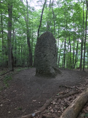
The Giants Thumb, mile 1496.1

The forest is warm and the humidity is about 70% today.  My shirt is completely soaked with sweat already this morning.  Even though some of this trail is easy the humidity is not favorable.


A view from the Lion's Head, mile 1502.0

I'm making good time traversing the distance from my camp. I've got a small resupply at the Salisbury post office.  I'm able to retrieve the box and secure a room at trail angel, Vanessa Breton's hostel/home.  The forecast is for severe thunderstorms this afternoon.  As I enjoy a steak and beer at the Lockup Restaurant, right next door to Vanessa's, the sky lights up and the thunder rocks the building, then the deluge starts and does not stop for 20 minutes. The rain is so hard that cars must pull over. I'm so glad I'm not in the forest as even with optimal tent placement and drainage channels I feel I would have trouble managing this amount of water. Tomorrow the forecast is the same, I plan on making the town of Great Barrington before the big event. 


Thursday, June 29, 2017

Caleb's Peak

  • Day:  110
  • Start:  1468.0
  • End:  1490.6
  • Miles:  22.6
  • Hours:  12
  • High temp:  84
  • Low temp:  62
  • Thru Hikers met:  3

 
Two twin fawns

I'm experiencing that deep sleep just prior to my alarm. I snooze the alarm for 30 minutes to get a little more. I'm on the trail by 0600 hrs enjoying the cool morning air.  A very short time from starting I came upon a doe nursing her two twins.  Everyone froze, as I reach for my camera the twins bolt, then mom does as well. So all I'm able to get is the twins on the trail. They keep running in front of me until they finally figured out to go sideways. 
A short but steep climb to Caleb's Peak is my first view of the day. 

Caleb's Peak

View form Caleb's Peak, mile 1470.8

Today is going to be lots of ups and downs. The grade is steep and I claw my way to the top with my trekking poles.  Another view location is Saint John's Ledges. 

The view from Saint John's Ledges, mile 1471.4

I continue the up and down process, with the humidity at about 65%  I'm sticky and sweaty.  I start another descent and notice this enormous rock. I guess I should have taken a panarama so I could show it all. 

The very huge rock

Now a rapid descent with some stone stairs and some jumbled rocks. This descent takes time because it is so steep.  Once at the bottom the trail follows the Housatonic River for about 5 miles.  Wow! What a great  easy walk this 5 miles is. 

The Housatonic River with day lillies

A refreshing change of pace

At one point I leave the river and skirt a field, no dew so it's a pleasure. 


More day lillies

Some daisies along the road

Now a climb away from the river.  Followed by more steep ups and downs. The climbs aren't long maybe 500', but darn they are steep.  Another trail builder challenge, a slot between a split boulder. 

How do they find these things?

More ups and downs, I'm getting fatigued as the day draws to a close. A final view looking west into Connecticut from Hang Glider View. 

Western Connecticut. Just out of the picture to the right is a race track with race cars on it.  Mile 1487.6

As I listen to the powerful race cars I descend into a valley.  Once at the valley floor I cross CT route 7, but before I continue on the trail I take a short walk to a closed vehicle repair shop.  Outside is a vending machine that offers Powerade.  I get 2 right off the bat. I sit on a bench and cool down while replacing my lost electrolytes.  One more for the road and I resume the trail.  The trail passes between a slow moving Housatonic River and a field then pops out into a highway. 


I'm a little concerned about a place to camp as the trail doesn't seem to be in the forest anymore.  I pass by the high school and notice there is a portapotty in the back. I divert to this area and find a spigot and a camp spot as well. Schools out and thus place looks deserted. Not my usual camping preference but it will have to do. 

Wednesday, June 28, 2017

Bull's Bridge

  • Day:  109
  • Start:  1445.8
  • End:  1468.0
  • Miles:  22.2
  • Hours:  13
  • High temp:  76
  • Low temp:  56
  • Thru Hikers met:  2


The Dover Oak, the oldest tree on the AT with a diameter of approximately 6 feet and estimated at over 300 years old

I slept in the shelter last night with one other hiker, Hooch. People are reluctant to sleep in the shelters now because of the bugs. The weather seemed cooler so I took a chance and it worked, the bugs disappeared after dark.  So right about dark about 8 other hikers straggled in, reminded me of why I like to camp away from shelters. For the most part the people left on the trail are courteous hikers as they have been doing this long enough to learn protocol. 
The shelter opening faces east so the sunrise is on display albeit through the forest. I'm on the trail by 0530 hrs. There is a deli/grill in 3 miles just off the AT, I plan on breakfast with some coffee and an electrolyte beverage. 
I drop down to a very swampy area with big grasses and a very nice boardwalk. 


Looking back to where the shelter was on the side of that hill


Another fancy boardwalk 


Just before I reach the highway I cross a train track.  There is an Appalachian Trail stop on weekends right here. 


A short walk down the highway gets me another delicious egg sandwich and the beverages I seek. Plus a bathroom and charging for my phone. While waiting for my order I have a conversation with a fellow who helped build the boardwalk I just crossed. He used to also maintain that section. 
Back on the trail as it goes through pastureland. Normally I enjoy the pastureland sections, but the grass is still wet and now so are my feet, just no way to avoid it.  I'll have to dry them out later. 


A fascinating silo

After a thorough soaking I'm thankfully back in the forest. I'm enjoying the energy of breakfast and walk briskly.  I cross a good size stream via an interesting bridge. 


The crib pier in the middle is the first I've seen on this trail. 


The wall of rock on the left made for a different feel. 

The forest scent this morning is freshly herbal with floral back notes, very uplifting. Yesterday I got some floral notes reminding me of gardenias.  Down another grade then a pleasant walk along a river. I cross a substantial steel bridge at the confluence of a tributary and the Hausatonic River.  A plush trail continues along the river until Bull's Bridge Road. I take the road for a short .3 mile walk across a covered bridge to a small convenience store where I enjoy a lunch and ice cream.


Bull's Bridge


Bull's Bridge Market

 I am able to get my shoes and socks dry in the sun, this makes my afternoon walk much better. 
More climbing and boardwalks as I come to another milestone the NY/CT boarder. 


Another state passed through. 


Another climb offers views of southern Connecticut and the Housatonic River Valley

The end of the day I cross a small pasture, I think to myself best to do this now than in the morning.  I cross a nice little stream where a fisherman has caught a few trout.  


Interesting bridge of logs. Actually very easy to walk across. 

Another splendid day hiking as I locate a good site and settle down for the night. 

Tuesday, June 27, 2017

Morgan Stewart

  • Day:  108
  • Start:  1426.2
  • End:  1445.8
  • Miles:  19.6
  • Hours:  10
  • High temp:  72
  • Low temp:  65
  • Thru Hikers met:  0

  
Western New York from Hosner Mountain, mile 1430.9
  
That tapping sound what is it?  I'm in a groggy state before my alarm goes off, I hear a soft tapping sound on my tent, it's a very light rain.  So I reset my alarm trying to get some more sleep while hoping it will stop.  Happily it stops at 0600 hrs and I'm packed and on the trail by 0630 hrs.  The bugs are out early and in force and they are trying to get me.  I spray repellent but they still torment. I'm close to the bug net, but not yet.  
I arrive at a highway with a deli and grill not far down the road.  I decide to make the trip for a late breakfast. I get the usual, a egg, bacon, cheese on a kaiser roll complemented with coffee and Gatorade.  There is a place to charge my phone and fill my water bottle. 


The Mountain Top Market

After breakfast I've got just 2 miles to complete my first 10 mile section. The trail is fast and I arrive at the Morgan Stewart Shelter for a break and some more water.  The interesting thing about the water here is it come from a pump. 


The hand pump that really works

I meet Phil a hiker who is out for a couple of weeks. Then 2 women arrive with their dog, Rhoan. They are just starting out their AT adventure. They left Bear Mountain and expect to go to  Katadan then flipflop to finish.  Actually this is a normal thing as there are new hikers on the trail just starting out. While we talk great peals of thunder echo off the mountains. I can see the dark clouds not too far away. We all wonder if rain is heading our way.  We all visit a while then I say my best wishes taking my leave. 
After a while on the trail I cross this bridge with a fast moving stream of muddy water   I suspect the thunder shower effected this drainage. 


The rain swollen stream

The sky darkens above me and I can feel the slight threat of rain. Then some drops start, but as I look up I see I'm on the edge of the storm so I hike on away from the clouds.  Perhaps I outran the storm because I didn't get wet. I did come across an attractive little pool the seemed so serene. 


Serenity

I come off the trail to a wide grassy road with a nice lake nearby. As I hike I get closer to Nuclear Lake,  I find a nice spot to rest while enjoying the beautiful lake and watching the afternoon thunderheads grow. 


Nuclear Lake

I'm getting close to my 20 mile mark and there is a shelter just about at that mark. I consider staying here just because of the rain threat. There is good water and a privy, these are always nice features.  Phil shoes up and he is going to tent. I figure I'll stay in the shelter.  The two women, Victoria , Nichole and Rhoan show up and decide to tent as well. 


 The Morgan Stewart Shelter

Monday, June 26, 2017

Shenandoah Mountain

  • Day:  107
  • Start:  1403.7
  • End:  1426.2
  • Miles:  22.5
  • Hours:  11
  • High temp:  74
  • Low temp:  65
  • Thru Hikers met:  4


Bear Mountain Bridge

By 0530 hrs I'm just two doors down at Perry's cafe. He makes an omelette the way I enjoy it with cheese and bacon plus there is lots of coffee. We chat between in and out customers for 45 minutes. Back at the motel I bring my pack out to the car as Doug steps out. I'm back on the trail by 0630 hrs, a nice respectable start.  Crossing the Hudson is he first order of business. 


Looking south on the Hudson River

Just prior to a highway is a boardwalk, I can hear the vehicles and even see a building. 


The trail crosses NY Route 9 and right there is the Appalachian Market.  This market has a small grill so I order an egg and bacon with provolone on a kaiser roll. I round out my meal with a large Powerade Zero.  So very nice to have places to get food do close to the trail. 


The Appalachian Market


My meal

The trail is nice today with moderate climbs and descents. I stop at a AT parking area to dump my garbage and top off my water from a convenient spigot.   Not to long after I see a deer. I speak nicely to her and she does not bolt. 


Another boardwalk through the biggest grasses I've seen yet.  


Yes the boardwalk is in there

Even though I'm in the forest and it feels remote, there are many times when neighborhood sounds or highway noise is heard. Today I'm passing through some remote neighborhoods so I hear construction sounds and garbage trucks as well as cars.  Seems strange compared to other trails where remoteness is so prevalent. 
I come to a pond that could have beavers.  I see a couple of water fowl but that's all. 


Beaver pond 

I find a quiet section of the trail.  The humidity and temperature are down to today making my hike much more pleasant. 


Now I'm on a section of nicely built trail. It is mostly level with few rocks.  A few places are elevated on rock causeways. 


Lot of work to build this nice causeway. 

The trail crosses NY Route 301 then follows high on a ridge along the length of Canopus Lake. 


The south end of Canopus Lake

I've reached my 20 mile mark and feel like I'm about done for the day. Plus the bugs are coming on. I start looking for a nice site. Before I find a place I get a another view of Canopus Lake. 


The northern end of Canopus Lake

I find a nice flat slab of rock on Shenandoah Mountain.  It is shielded from the trail and main rock slabs by a stand of brush. I think it's a good spot because of the cooling breeze and open feel.